

The Jordan Valley
The Jordan Valley , which extends down the entire western flank of Jordan Jordan Valley forms part of the Great Rift Valley of Africa, which extends down from southern Turkey through Lebanon and Syria to the salty depression of the Dead Sea, where it continues south through Aqaba and the Red Sea to eastern Africa . This fissure was created 20 million years ago by shifting tectonic plates.
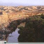
The northern segment of the Jordan Valley Dead Sea . TheJordan River rises from several sources, mainly the Anti-Lebanon Mountains in Syria , and flows down into Lake Tiberias (the Sea of Galilee ), 212 meters below sea level. It then drains into the Dead Sea which, at 407 meters below sea level, is the lowest point on earth. The river is between 20 and 30 meters wide near its endpoint. Its flow has been much reduced and its salinity increased because significant amounts have been diverted for irrigational uses. Several degrees warmer than the rest of the country, its year-round agricultural climate, fertile soils, higher winter rainfall and extensive summer irrigation have made the Ghor the food bowl of Jordan
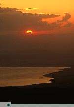
The Jordan River ends at the Dead Sea , which, at a level of over 407 meters below sea level, is the lowest place on the earth’s surface. It is landlocked and fed by the Jordan River and run-off from side wadis. With no outlet to the sea, intense evaporation concentrates its mineral salts and produces a hypersaline solution. The sea is saturated with salt and minerals–its salt content is about eight times higher than that of the world’s ocean–and earns its name by virtue of the fact that it supports no indigenous plant or animal life. The Dead Sea and the neighboring Zarqa Ma’een hot springs
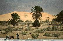
Wadi Araba. © Zohrab South of the Dead Sea, the The seaside city of |


0 التعليقات:
Post a Comment