

The Mountain Heights Plateau
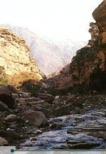
Wadi Mujib. © Jad Al Younis, Discovery Eco-Tourism
The highlands of Jordan separate the Jordan Valley Jordan ’s main population centers, including Amman Petra Jordan
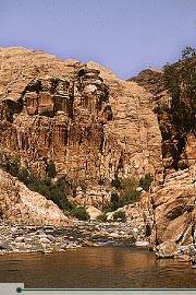
Wadi Finan. © Jad Al Younis, Discovery Eco-Tourism
The region, which extends from Umm Qais in the north to Ras an-Naqab in the south, is intersected by a number of valleys and riverbeds known as wadis. The Arabic word wadi means a watercourse valley which may or may not flow with water after substantial rainfall. All of the wadis which intersect this plateau, including Wadi Mujib, Wadi Mousa, Wadi Hassa and Wadi Zarqa, eventually flow into the Jordan River, the Dead Sea or the usually-dry Jordan Rift. Elevation in the highlands varies considerably, from 600 meters to about 1,500 meters above sea level, with temperature and rainfall patterns varying accordingly.
The northern part of the Mountain Heights Plateau, known as the northern highlands, extends southwards from Umm Qais to just north of Amman Land of Gilead
South and east of the northern highlands are the northern steppes, which serve as a buffer between the highlands and the eastern desert. The area, which extends from Irbid through Mafraq and Madaba all the way south to Karak, was formerly covered in steppe vegetation. Much of this has been lost to desertification, however. In the south, the Sharra highlands extend from Shobak south to Ras an-Naqab. This high altitude plain receives little annual rainfall and is consequently lightly vegetated.


0 التعليقات:
Post a Comment