Powered By Blogger

Touristic Sites In Jordan

Amman is the capital of the Hashemite Kingdom Of Jordan Near Amman (AlSalt,Wadi Seer) 1-- North and West of Amman(Jerash,‘Ajloun,Irbid,Umm Qais,Hemma,Umm al-Jimal) The Jordan Valley(The River Jordan,The Dead Sea,Deir Ain Abata Deir ‘Alla,Tabaqat Fahl) 2-- East of Amman: The Desert Castle Loop(Qasr al-Hallabat,Azraq Oasis,Qasr al-Azraq,Shomari Wildlife Reserve ,Qusayr ‘Amra,Qasr al-Harraneh,Qasr al-Mushatta Qastal) 3-- South of Amman(The King’sHighway,Madaba,MountNebo, Mkawer,Hammamat Ma’een,Karak,Khirbet al-Tannur,Tafileh ,Shobak,Dana Nature Reserve Wadi Rum) 4-- Petra 5-- Aqaba 6-- The Ancient Holy Land 7-- Islamic Holy Sites in Jordan
Showing posts with label Christianity. Show all posts

Friday, February 17, 2012

Umm al-Rasas


Umm al-Rasas (also spelled Umm ar-Rasas and Um er-Rasas) is an important archaeological site that was declared a World Heritage Site in 2004. Its structures date from the 3rd to 9th centuries and most have not yet been excavated. The site is especially known for its magnificent Byzantine mosaics, which have been uncovered in two churches dating from the 6th and 8th centuries.
History

This site has been inhabited since at least the Iron Age (7th century BC), as attested by artifacts such as a basalt pillar base and a stone scarab. In ancient times, it was a Moabite town called Kastron Mefaa. The prophet Jeremiah mentioned the city (as "Mephaath") in his condemnation of Moab (Jeremiah 48:21). The 4th-century church historian Eusebius recorded that a Roman army unit was stationed here.

Excavations began in 1986 at the north end of the site and have continued ever since. Most of the site still remains buried under rubble.

What to See

The jumbled ruins of Umm al-Rasas are enclosed inside a wall with gates on the north, south and east sides, with more structures spreading outside the walls to the north. Archaeologists have focused their work on the Byzantine churches, of which four inside the walls and 11 outside the walls have been discovered so far. In addition to the churches, two oil presses and a winery have been uncovered.

Inside the walls, the most notable ruins are two churches built into the east wall, the Church of the Rivers and the Church of the Palm Tree. Both are named for their mosaics and date from the 6th century. The area around the churches has also been excavated, revealing several arched rooms and a courtyard with wells and basins.

Outside the northeast corner of the walls is the Church of the Lions, named for its mosaic that includes two lions. Finally, at the northeastern corner of the site, are the two most famous churches at Umm al-Rasas - the Church of Bishop Sergius and the Church of St. Stephen - which are sheltered under a green hangar.

Bishop Sergius' Church (587 AD) lies to the north. Next to its altar is a rectangular mosaic floor decorated with rams, pomegranate trees, and an inscription dating the mosaics to the time of Bishop Sergius. The nave mosaic has portraits of donors and personifications of the Sea and Earth, but these were badly damaged by iconoclasts.

Mosaics of St. Stephen's Church
The celebrated Church of St. Stephen (785 AD) has a magnificent mosaic floor throughout the interior. The dedicatory inscription provided the date of the mosaic and, importantly, identified Umm ar-Rasas as the ancient city of Kastron Mefaa. Below the inscription are the outlines of donor portraits, which were removed by iconoclasts, and fruit trees.
The central panel of the nave mosaic - featuring roundels with agricultural and hunting motifs - is badly damaged, but it is the border that gets the most attention anyway. Creating a wide rectangular frame around the nave are mosaic depictions of 15 major cities as they appeared in the 8th century, each labeled in Greek. Those on the north side are in Palestine; those on the left are in Jordan.
Jerusalem has pride of place next to the altar, labeled as "Holy City" (HAΓIA ΠΩΛIC). Next to it is Kastron Mefaa itself, represented by a pillar and a church. The remaining Jordanian cities are Philadelphia (Amman), Madaba, Esbounta (Hesban), Belemounta (Ma'in), Areopolis (Rabba) and Charachmoba (Karak). Beneath Jerusalem are the Palestinian cities of Nablus, Sebastis, Caesarea, Dispolis (Lidda), Eleutheropolis (Beit Gibrin), Askalon and Gaza. At the top of the side aisles are two more Jordanian towns, Limbon and Diblaton.

Stylite Towers
Two square towers north of Umm al-Rasas were probably used by stylite hermits, who once flourished in this part of the world. These hardy souls spent many years living in austerity atop a pillar, often attracting many admirers below. The most famous of these hermits is St. Simeon Stylites whose church still survives in Syria.
UNESCO notes that these towers are "probably the only remains of the practice." They are solid inside except for a small room at the top. The east face has a carved niche and the remaining sides are carved with Greek crosses. Near the towers are various ruins, include a little church with an apse (east of the tower).

Quick Facts

Site Information
Names:Umm al-Rasas; Um er-Rasas; Umm ar-Rasas; Kastrom Mefa'a; Kastron Mefaa, Mephaath
Location:Jordan
Faith:Christianity
Categories:City Ruins; Churches; World Heritage Sites
Architecture:Byzantine
Date:3rd-9th centuries
Features:Byzantine Mosaics
Status:ruins
Visitor Information
Coordinates:31.50089° N, 35.920519° E   (view on Google Maps)
Lodging:View hotels near this location

Kerak Castle


Kerak Castle

South of Madaba on the old King's Highway is Kerak, which was the capital of the biblical kingdom of Moab. Perched atop a steep hill, Kerak is a predominantly Christian town dominated by the largest and best preserved of the Crusader castles in the region.

History

Once an important city of the Biblical kingdom of Moab, Kerak was also home to the Nabateans, Romans (from 105 AD), and the Byzantines, before the Crusaders built a castle here. In the Byzantine period Kerak was a bishopric and it remained mostly a Christian town even under Arab rule.
In 1126, Payen le Bouteiller (Paganus the Butler) received Kerak from King Baldwin II of Jerusalem as part of the lordship of Oultrejourdain (Transjordan). In1142, he built Kerak Castle over the existing foundations on the site.
Kerak Castle replaced Shobak as the center of the Transjordan and became the most important in a series of fortresses between Jerusalem and Aqaba. The Crusaders set up an impressive system of security: all the fortifications were a day's journey apart and each one lit a beacon at night to inform Jerusalem it was safe.
Kerak Castle resisted attacks by Saladin's troops in 1183 and 1184, but finally fell after a siege in 1189. The Mamluk ruler Baybars added a tower on the northwest corner in 1263. It was later owned by local families until 1840, when Ibrahim Pasha of Egypt captured the castle and destroyed much of it in the process.
After World War I, Kerak was administered by the British until the Emirate of Transjordan was established in 1921. Kerak is still a predominantly Christian town, with many of today's inhabitants tracing their roots back to the Byzantines.

What to See

Kerak Castle is a typical example of Crusader architecture, with Romanesque-style stone vaults, numerous corridors, and strong doorways. The Crusader parts of the ruins are mostly on the upper level and can be identified by their dark volcanic tufa; later Arab additions are in white limestone.
Through a massive door (ask at the ticket office), steps lead down to vast, dimly-lit, vaulted rooms and corridors underground.
The upper courtyard includes the remains of a Crusader chapel and provides excellent views over the Jordanian landscape to the Dead Sea.
The west wing of the complex is home to the small Kerak Archaeological Museum, which displays artifacts excavated at the site.

Quick Facts

Site Information
Names:Kerak Castle; Krak Castle; Crak des Moabites; Krak des Moabites; Le Pierre du Desert; Charach Mouba
Location:Jordan
Faith:Christianity
Denomination:Catholic
Category:Castles and Palaces
Architecture:Romanesque
Date:1142-89
Patron(s):Payen le Bouteiller
Status:ruins
Visitor Information
Address:El-Mujamma Street, Kerak, Jordan
Coordinates:31.180827° N, 35.70133° E   (view on Google Maps)
Lodging:View hotels near this location
Phone:            03-235-1216       (museum)

Jerash, Gerasa


Jerash , Gerasa

Dubbed the "Pompeii of the East," Jerash is a Greco-Roman ruined city located 80 miles north of Amman. The impressive, beautifully preserved ruins of Jerash include places of worship and other buildings from the Hellenistic, Roman, Byzantine and early Muslim periods.

History

In the 3rd century BC, during the Hellenistic era, Jerash became a member of the Decapolis, a federation of Greek cities. It was then known as Gerasa.

Gerasa and other Decapolis cities were conquered by Pompey in 63 BC, which ended up being a positive development. Jerash enjoyed semi-autonomous status and considerable prestige as part of the Roman province of Syria, during which it prospered from its position on the incense and spice trade route.

Jerash lost its autonomy under Emperor Trajan, but his annexation of Petra in 106 AD brought the city even more wealth. A favorite city of Hadrian, who stayed there in the winter of 129-30, it flourished both economically and socially in the 2nd century. Several temples were built during this period, including the Temple of Artemis (in 150 AD) and Temple of Zeus (in 162 AD).

After a period of decline in the 3rd century, Jerash was reborn as a Christian city under the Byzantines. It flourished especially during the reign of Justinian (527-65), during which at least seven churches were added to the city.

The last church was built in 611, but it all went downhill from there. The city was invaded by Persians in 614, captured by Muslims in 635 and badly damaged by several earthquakes in the 8th century.

In 720, Caliph Yazid II decreed that "all images and likenesses in his dominions, of bronze and of wood and of stone and of pigments, should be destroyed." Obedience to this command can be seen in the mosaics of some of Jerash's churches, such as that of St. John the Baptist. But others, already so ruined that their mosaics were not visible (such as the Church of Sts. Cosmos and Damianus), escaped the destruction

By the time the Crusaders arrived in the 12th century, Jerash had been unhabited for some time. Unfortunately, a garrison stationed in the area by the Atabey of Damascus made the Temple of Artemis into a fortress, which was captured and completely destroyed (apparently by fire) by King Baldwin II of Jerusalem in 1112.

Excavations of Jerash began in the 1920s and are still going on today.

What to See

Jerash is a large and fascinating archaeological site. Visitors enter on the south side through Hadrian's Arch, built in honor of its namesake. Nearby is the Hippodrome, where chariot races and sporting events were held. A little way down the track is the South Gate, part of the 4th-century AD city wall.

The Temple of Zeus overlooks the spacious Oval Plaza, which measures 90 x 80m. Surrounded by a colonnade of 1st-century Ionic columns, it had two altars in the middle that were replaced with a fountain in the 7th century AD. A central column was recently erected to carry the Jerash Festival flame.

From the Oval Plaza, a staircase leads up to the sacred precinct (temenos) of the Temple of Zeus (162 AD). Another staircase led to the temple itself, which was surrounded by 15 m high Corinthian columns.

Stretching north from the Oval Plaza is the Cardo Maximus, the main Roman road in Jerash. It is still paved with its original stones and bears the ruts of chariot wheels. As part of a remodeling of the street around 170 AD, the original Ionic columns were replaced with a more decorative Corinthian colonnade. The Cardo was lined with a broad sidewalk and shops and an underground sewage system ran the full length of the street, into which rainwater was channeled through holes on the sides of the street.

Not far from the Oval Plaza on the right is the onsite Archaeological Museum, which houses a fascinating collection of artifacts found at the site, including gold jewelry, coins, glass and even pottery theater tickets.

The colonnade of the Cardo becomes taller at the entrance to the marketplace (Macellum), a ruined structure on the left. Here there is a fountain with a lion's head dated to 211 AD. The next structure down the Cardo after the marketplace is a recently discovered Umayyad Mosque, where excavations are still underway.

Shortly after the mosque is the South Tetrapylon that marks the intersection of the Cardo with the South Decumanus, a smaller street running east to west. Only the lower parts of the four columns marking the intersection remain today.

Continuing north on the Cardo, the next building on the left is the richly carved gate of the 2nd-century Roman Temple of Dionysus, which was rebuilt as a Byzantine church in the 4th century. It has been dubbed the "Cathedral," but there is no evidence this was the bishop's church. At the top of the stairs against the east wall is a Shrine of the Virgin Mary, with a painted inscription to St. Mary and the archangels Michael and Gabriel.

Just behind the Cathedral is the large Church of St. Theodore, built in 496 AD. In between the two churches is a small paved plaza with a fountain in the center, which was originally the Cathedral atrium.

Behind St. Theodore on the far west of the site, the ruins of three Byzantine churches are grouped together around a shared atrium. The northernmost is the Church of St. Cosmos and St. Damian, dedicated to twin brother doctors who were martyred in the 4th century (they have a fine church in Rome as well). This church has the most splendid floor mosaics to be seen in Jerash. An inscription dates the mosaic to 553 AD. The images include the churchwarden Theodore and his wife Georgia praying with widespread arms.

The middle of the three churches is that of St. John the Baptist, dating from 531 AD. Its mosaic floor, now damaged, included images of the four seasons, plants and animals, and the cities of Alexandria and Memphis in Egypt. The church of St. George, the southernmost, was built in 530 AD. It continued to be used after the earthquake of 749 AD, and its mosaics were destroyed when the 8th century Christian iconoclastic movement banned the representation of humans and animals.

Back on the Cardo, just north of the Cathedral is a large nymphaeum, or monumental fountain. It was constructed in 191 AD and was faced with marble. Next is the Propylaeum or gateway that led to the sacred precinct of the Temple of Artemis (150 AD), which occupies a large site to the left of the Cardo. A monumental staircase, which once had high walls, leads up to a horseshoe-shaped terrace with the foundations of an open-air altar. A second staircase leads through a colonnade of 22 Corinthian columns and into the Temenos (sacred precinct), which measures 162 x 121 m and had Corinthian columns on all sides.

In the 6th century, a Byzantine church (the "Propylaeum Church") was built opposite the Propylaeum on the site of a courtyard that formed part of the processional way to the Temple of Artemis. The courtyard's columns were incorporated into the church.

Past the Temple of Artemis and left of the Cardo is a small theater or Odeon, built in 165 AD and doubled to its present size in 235 AD. West of the Odeon is the Church of the Bishop Isaiah, built in 559 and used until the earthquake of 749. Here the Cardo intersects with the North Decumanus, which is marked by the North Tetrapylon. In the 2nd century this probably had a domed roof and elaborate carved decoration.

Festivals and Events

The Jerash Festival is held each year for 2 weeks in July (contact Jordanian Tourism Information offices or www.jerashfestival.com.jo for current information).

Tip: School trips to Jerash usually occur on Wednesdays.

Quick Facts

Site Information
Names: Jerash
Location: Jordan
Faiths: Original/Primary: Ancient Roman
Current/Secondary: Christianity
Categories: City Ruins; Roman Temples
Architecture: Classical, Paleochristian
Status: ruins

Visitor Information
Coordinates: 32.281899° N, 35.891004° E   (view on Google Maps)
Lodging: View hotels near this location
Phone: Jerash Visitors' Center: 04/451-272
Jerash Archaeological Museum: 04/452-267

Mount Nebo


Mount Nebo


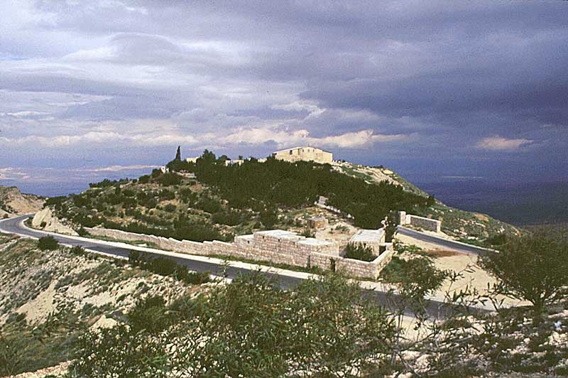
Mount Nebo is a 1,000m (3,300ft) high mountain located 10km/6 mi NW of Madaba in Jordan, opposite the northern end of the Dead Sea. According to ancient tradition, this is the mountain from which Moses saw the Promised Land before he died.

Because of its connection to Moses, Mt. Nebo has long been an important place of Christian pilgrimage. Excavations led by the Franciscans, who own the site, have uncovered significant remains of the early church and its magnificent Byzantine mosaics. A simple modern shelter dedicated to Moses has been built over them.

What to See

Rising over 700m above the Jordan Valley, Mount Nebo offers spectacular views of the Promised Land as seen by Moses. On the platform at the summit is a modern sculpture by an Italian artist representing Moses' staff and Jesus' words in John 3: "As Moses lifted up the serpent in the wilderness, so must the Son of Man be lifted up."

Elements of a triple-apse Byzantine basilica were uncovered by archaeologists in the 1930s, and have been incorporated into the structure of the modern church building, known as the Memorial Church of Moses. The modern additions to the church are very simple, consisting of little more than a shelter over the fascinating excavations and ancient mosaic floors.

Just inside the entrance to the left is the excavated Old Baptistery, which has one of the most interesting ancient mosaics in Jordan. The baptistery and the mosaic can be precisely dated to August 531 thanks to a Greek inscription, which also names the three workers who created it and the bishop at the time (Elias).

The Old Baptistery mosaic is in remarkably pristine condition because another one was laid over it just a few decades later in 597. The underlying mosaic remained hidden for nearly 1,400 years until it was discovered in 1976 when the one on top was removed for restoration (it now hangs on a wall).

The mosaic of 531 is a large square divided into four strips of scenes of men and animals, surrounded by a chain-style border. The top two sections depict fierce hunting scenes: a shepherd fighting a lion, a soldier fighting a lioness, and two horseback hunters defeating a bear and wild boar.

The lower scenes are pastoral but with a touch of the exotic: a shepherd watching his goat and sheep graze in the shade of trees; an ostrich on a leash held by a dark-skinned man; and a boy holding the leashes of a zebra and a spotted animal that looks very much like a camel but might be intended to represent a giraffe.

There are more mosaics in the nave and side aisles of the church, including some fragments of the 597 mosaic pavement. The oldest mosaic in the church is a braided cross displayed on the south wall.

Also hanging here are mosaics of animals from the Church of George in Mukhayyat. One of these is from 536 and has an inscription that some believe is the earliest example of Arabic script in Jordan (others argue it is old Aramaic).

In the far right-hand corner of the church is the New Baptistery (597 AD), which was previously a funerary chapel. It includes a small mosaic originally from the threshold bearing the greeting, "Peace to all."

Next to the New Baptistry, a lovely mosaic cross from the original 4th-century church stands on a modern altar in its original location. A photograph of the Pope praying at the same altar is proudly displayed.

Next to the exit door is the Theotokos Chapel, added in the 7th century where three rooms of the monastery previously stood. Its apse has a mosaic of a square object that may be a ciborium (vessel for the Eucharist) or altar canopy, accompanied by bulls and gazelles. The floor of the chapel is paved with mosaics of plants and flowers.

Foundations of the ancient monastery are visible outside.

In The Holy Quran
(Red Dune)
Site and the death of the Prophet Moses on Mount Nebo
Moses is the prophet who said a lot in the Koran( The Holy Quran ), and many of the events of his life and his missions dealt with in detail and the Koran( The Holy Quran ) includes the following:
· Birth and growing up in the court of Pharaoh.
· His escape to the debtor and his marriage to the daughter of Prophet Shuaib .
· Going to the Pharaoh with his brother Aaron and his miracles, which was endorsed by God.
· His escape with the children of Israel from Egypt with God and his words and hit the rock and the anger of his people when they worshiped the calf made ​​of gold.

The monuments in the Madaba Governorate:
1. Mount Nebo
Temple serves it back to the time of Moses, peace be upon him, and within the mosaic map.
2. The effects of the Church of Byzantium in the calculus.
3. Prophet Yahya
Site of his death in Mukawer / Madaba.

In the Bible

Then Moses climbed Mount Nebo from the plains of Moab to the top of Pisgah, across from Jericho. There the Lord showed him the whole land.... Then the Lord said to him, "This is the land I promised on oath to Abraham, Isaac and Jacob when I said, 'I will give it to your descendents.' I have let you see it with your eyes, but you will not cross over into it."

And Moses the servant of the Lord died there in Moab, as the Lord had said. He buried him in Moab, in the valley opposite Beth Peor, but to this day on one knows where his grave is. --Deuteronomy 34:1-6
History

In the 4th century AD a sanctuary, mentioned by the pilgrim nun Egeria, was built on Mount Nebo (Fasaliyyeh in Arabic) to honor Moses, possibly on the site of an even older structure. The church was finished by 394 AD and had three east apses flanked by funerary chapels on the north and south sides.

In the 6th century, the church was enlarged and transformed into a basilica with a sacristy and new baptistery (whose surviving floor mosaics date from c.530 AD). Soon the church was the heart of a large monastery and pilgrimage center that would thrive for nearly six centuries.

The site was abandoned by 1564 and remained mostly neglected for several centuries more. Finally, in 1993, the site was purchased by the Franciscans, who excavated and restored the area. On March 19, 2000, Pope John Paul II visited the site during his pilgrimage to the Holy Land, planting an olive tree next to the Byzantine chapel for peace.

Today, Mount Nebo is an active Franciscan monastery, the headquarters of the Franciscan Archaeological Institute, and a popular stop for pilgrims and tourists alike.


Catholic Encyclopedia
(Septuagint: Nabau).

A mountain of the Abarim range east of Jordan and the Dead Sea, from which Moses surveyed the Promised Land (Deuteronomy 32:49), and where he died (Deuteronomy 34:1-5). The same is probably mentioned in the wanderings in Numbers 33:47: "And departing from Helmondeblathaim, they came to the mountains of Abarim over against Nabo" (Hebrew Nebo), though here the reference may be to the town (see NABO). The location of Mount Nebo is doubtful. A comparison of Deuteronomy 3:27 (cf. Numbers 27:12) with Deuteronomy 32:49 indicates that the "top of Phasga" and Nebo were variant names referring to the same spot. Difficulty arises in that from no point of the Abarim range does it seem possible to behold all the territory mentioned in Deuteronomy 34:1-3, especially if the "furthermost sea" means the Mediterranean, as in Deuteronomy 11:24. By some Nebo is identified with the modern Jebel Neba, an oblong ridge on an elevated plateau five miles south-west of Hesebon, 2700 feet above sea level.

Quick Facts

Site Information
Names: Mount Nebo; Siyagha (from Aramaic for "monastery"); Moses Memorial Church; Memorial Church of Moses
Location: Jordan
Faith: Christianity
Denomination: Original/Primary: Byzantine
Current/Secondary: Catholic
Order: Franciscan
Dedication: Moses
Categories: Sacred Mountains; Biblical Sites
Architecture: Byzantine
Date: Church built 394 AD, expanded in 500s AD
Features: Byzantine Mosaics
Status: active

Visitor Information
Address: Mount Nebo, P.O.Box 2 Faysaliyah, 17196 Madaba, JORDAN
Coordinates: 31.767717° N, 35.725624° E   (view on Google Maps)
Lodging: View hotels near this location
Public transport: Mount Nebo can be reached by taking a bus from Madaba then walking the remaining 4km/2.5mi, or taking a taxi from Madaba.